Haute-Sorne: Building Sustainable Shallow Geothermal Heating Solutions to transform a Municipality
A comprehensive energy planning initiative to transform the commune of Haute-Sorne's heating infrastructure, achieving a 91% reduction in CO₂ emissions through strategic deployment of sustainable building heating solutions and advanced geospatial analysis.
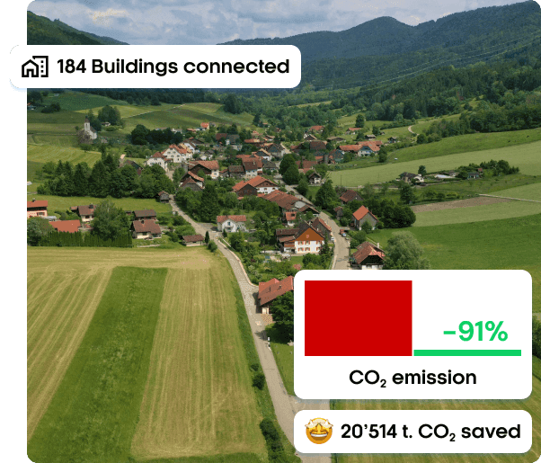
- 91%CO₂ Emission Reduction
- 80%Coverage Efficiency
- 184Buildings Connected
Company details
Geoimpact AG is a Swiss territorial energy planning specialist providing comprehensive solutions from analysis through implementation across Bern, Zürich, and Basel regions.
The challenge
The commune of Haute-Sorne faced the complex challenge of bringing sustainability to its heating system across a diverse building portfolio. With 103 GWh of annual energy demand distributed across nearly one million square meters of heated space, the municipality needed a data-driven approach to:
- Identify optimal district heating network locations across diverse building typologies
- Quantify potential CO₂ emission reductions
- Evaluate economic feasibility of different heating technologies and scenarios
- Prioritize investments for maximum CO₂ emissions reduction impact
Traditional heating solution planning lacked the granular analysis needed to optimize network topology and technology selection at territorial scale.
The solution
Geoimpact deployed TESSA clustering technology to conduct comprehensive geospatial energy analysis of Haute-Sorne's building stock, prioritizing the sustainable heating solution to buildings with the highest emissions.
The methodology combined advanced clustering analysis, archetype-based demand modelling, and scenario comparison to identify five optimal network zones.
The results
The solution demonstrated that targeted district heating networks can deliver emission reductions of up to 91% while connecting 184 buildings across the commune — a result that conventional planning approaches were unable to surface.
TESSA gave us the clustering granularity we needed to compare scenarios at municipal scale without losing per-building precision.